17.15.030 Specific Plat Requirements:
Final plats shall include all survey map requirements required by state law, all requirements pertaining to the preliminary subdivision approval, and the following specific items:
A. A title box shall be on all sheets of the plat, and shall identify the business name of the firm or land surveyor that performed the survey.
B. Each sheet of the plat shall be numbered consecutively with a sheet identification number such as “Sheet 1 of 2”.
C. Each sheet shall have an identical heading at the top of the sheet. The heading shall be written per the following format, with modifications approved such that an accurate description is provided for the underlying property:
(Name of the subdivision) Short Plat (or Major Plat)
If applicable - A Replat of (list the underlying subdivision; or the portion thereof, with lot and block numbers)
A Portion of the ___________ 1/4 of the ___________1/4 of Section ___________, Township ___________ N., Range ___________ E. WM., Moses Lake, Grant County, Washington.
D. The Grant County Auditor’s Certificate shall be on the first sheet of the plat and read as follows:
GRANT COUNTY AUDITOR’S CERTIFICATE
Filed for record this ___________day of ___________, ___________at ___________O’clock ___________M. in Book ___________ of Major Plats (or Short Plats) at Pages ___________ through ___________, records of Grant County, at the request of the City of Moses Lake.
___________
Grant County Auditor
___________
by Deputy Auditor
E. The Surveyor’s Certificate shall be on the first sheet of the plat and read as follows:
SURVEYOR’S CERTIFICATE AND DECLARATION
I hereby certify that this plat is a true and correct representation of the lands actually surveyed.
I hereby declare that the (Plat Name) (Major or Short Plat) is based on an actual survey and subdivision of a portion of Section ( ), Township ( ) North, Range ( ) East, W.M.; that the survey was completed by me or under my direction; and that the distances, courses and angles are shown thereon correctly to the best of my knowledge, information, and belief; and that proper monuments have been set and lot corners are staked on the ground.
F. The address and signature of the Land Surveyor shall be on the first sheet of the plat.
G. The seal and date that the land surveyor stamped the plat shall be shown on each sheet of the plat.
H. The date of the survey shall be shown on the first sheet of the plat.
I. The north arrow, which is based on the bearing datum, shall be shown on each sheet that includes a plan view of the subdivision or a vicinity map.
J. A bearing datum and vertical datum shall be described on the first sheet of the plat
When GPS is used to derive the bearings and elevations shown on the plat, the NAD 83 and NAVD 88 datums shall be used, and shall be stated in the Bearing Datum and Vertical Datum. Furthermore, the difference between the NAVD 88 elevation datum and the USBR elevation datum shall be shown in the Vertical Datum.
When GPS is not used to derive the bearings and elevations, a bearing from a recorded document shall be shown between two primary control points. The primary control points shall be existing monuments that were found during the survey for the plat. Survey information for the primary control points shall be shown on the plat, which information shall tie the primary control points to the plat boundaries. The vertical datum shall be the USBR elevation datum.
K. All subdivision boundaries, block boundaries, and lot boundaries shall be identified by straight line segments or curve line segments.
L. All straight line segments and curve line segments that are described in the legal description shall be shown on the plat.
M. All straight line segments on the plat shall include a bearing and a distance.
N. All bearings shall be based on the approved bearing datum shown for the survey. The bearings shall be in degrees, minutes, and seconds; to the nearest second.
O. All distances shall be to the nearest one-hundredth of a foot. When using distances derived from GPS, a note shall be placed on the first sheet of the plat that states the shown distances are ground distances.
P. When a straight line segment is compiled as several straight line segments, the dimensions shall be rounded as necessary such that the summation of all the straight line segments shall be equal to the distance shown for the larger straight line segment or segments.
Q. Where a distance and bearing or curve data is shown on the plat that spans more than two (2) points, leader lines shall be provided to clearly show the end points of the described line segment.
R. All curves on the plat shall include delta angles, curve lengths, and curve radii.
S. When straight line segment or curve line segment data are compiled in a table, the curve line segment and straight line segment data shall be labeled consistently throughout the plat.
T. Tables for straight line segment and curve line segment data shall be shown on the same sheet on which the straight line segment or curve line segment is shown.
U. All boundaries for existing and proposed right-of-way, municipal easements, public land, and public utility easements, within and abutting the subdivision boundaries, shall be labeled on the plat and defined by the survey.
V. A graphical scale shall be shown for each survey map. Plat scales shall be drawn one hundred feet (100') per inch, or at an alternate scale that is approved by the Municipal Services Director. Alternate scales shall be at ten (10), twenty (20), thirty (30), forty (40), fifty (50), or sixty (60) feet per inch; or multiples of ten (10) to these six (6) scales.
W. Street names shall be shown on the plat for all streets being dedicated on the plat. Street names are authorized if they can be printed on a standard street name sign, they are not similar sounding to existing street names in the vicinity of Moses Lake, and they are not offensive in nature. Approved street names shall be shown on the final plat mylars.
X. Final mylar plats shall be suitable for microfilming and digital filing, such that the quality of the microfilm and digital file are not diminished.
Y. Final mylar plats shall be drawn without cross hatching, shading, and other highlighting techniques that diminish the legibility of the details or text on the plat.
Z. All drafting details and text shall be drawn on the plat such that they are not overlapping and all details and text are distinguished independently from each other.
AA. All text on the plat shall be no smaller than eight-hundredths (0.08) of an inch, except that a smaller text is authorized on vicinity maps and land surveyor seals, provided that the smaller text is legible.
BB. Final mylar plats shall not include adhesive materials affixed to the surface.
CC. Information shall be shown on the plat to describe the permanent monuments that are shown for the survey. Such information shall include the type and size of the monument, type of encasement, and the latest date for all monuments found, established, or reestablished. Information about the monuments shall include the condition of the monument. If the monument defines a section corner, street intersection, or property boundary, that information shall be shown on the plat. When the surveyor does not accept the existing monument(s) for marking the intended locations, then the surveyor shall set a monument at the location that the surveyor has established.
DD. Deed information along the boundaries of the plat shall be shown on the plan view of the subdivision. Deed information shall be clearly identified and referenced such that it is not mistaken for the current survey information.
EE. The elevations of all subdivision boundary corner monuments shall be shown on the plan view of the subdivision and shall be based on the vertical datum. Elevations shall also be shown for existing monuments that are used to tie the subdivision boundary to the primary control monuments.
FF. All ambiguities, hiatuses, and overlapping boundaries shall be identified on the plat.
GG. Final mylar plats shall be either photo mylar with a fixed halide base, or permanent black ink on mylar that is coated with a suitable substance to assure permanent legibility.
HH. All signatures and writing on final mylar plats shall be in permanent, black ink.
II. All sheets shall have blank borders of no less than two inches (2") on the left margin, three-fourths inch (3/4") on the top border, and one-half inch (1/2") on the remaining two (2) margins.
JJ. All sheet sizes shall be either eighteen inches (18") by twenty-four inches (24"), or twenty-four inches (24") by thirty-six inches (36").
KK. A vicinity map shall be shown on the first sheet of the plat. The vicinity map shall show sufficient property surrounding the plat such that streets in the area are shown. All existing streets within the area of the vicinity map shall be labeled. The Municipal Services Director may approve the vicinity map to be placed on the second sheet of the plat when space constraints exist on the first sheet. The scale of the vicinity map shall be shown.
LL. All USBR irrigation and drainage water rights-of-way within and abutting the subdivision shall be shown and labeled on the plat, with sufficient information, such that the location is defined with respect to the subdivision boundaries.
MM. Property that abuts the subdivision shall be identified on the plat, including public areas, such as parks, streets, playgrounds, and the lake. Sufficient information shall be shown on the plat such that the locations of these areas can be determined with respect to the boundary corners of the subdivision.
NN. Information about existing recorded right-of-way, municipal easements, public land, and public utility easements within or abutting the subdivision shall be shown on the plat. Copies of said records shall be included by the applicant with the preliminary subdivision application. All City right-of-way within the plat shall be previously deeded property, previously dedicated to the City, or shown as dedicated to the City of Moses Lake.
OO. Names of existing subdivisions that abut the boundaries of the subdivision, or which existing subdivisions abut adjacent right-of-way to the subdivision, shall be shown on the plat. When the adjacent property is unplatted, the property shall be labeled as “unplatted”.
PP. All municipal dedications provided by the owner upon recording the plat shall be explicitly shown on the plat. Municipal dedications shall be accompanied by the note “Dedicated to the City of Moses Lake”.
QQ. Other dedications of public land shall be explicitly shown and described with sufficient language to establish that the dedication is provided with the recording of the plat.
RR. Transmission line easements are authorized to be shown on the plat, provided that sufficient information is shown to describe the location of the easements with respect to the subdivision. Other private easements shall not be shown on the plat, but recorded documents of private easements may be required for review purposes.
SS. All municipal boundaries, township lines, section lines, and street centerlines shall be shown on the plat if said lines are within the range of the survey or adjacent to the subdivision. Any of the said lines that are coincident with each other shall be identified as such on the plat.
TT. Abbreviations that are used on the plat shall be defined in the legend for the plat. However, the following abbreviations that are defined below do not require a definition in the plat legend.
|
± |
more or less |
|
AFN |
auditor’s file number |
|
B.C. |
brass cap |
|
E., W., N., S. |
East, West, North, or South, respectively |
|
in |
inch |
|
I.P. |
iron pipe |
|
ft |
foot |
|
M.L. |
Moses Lake |
|
Mon. |
monument |
|
Mun. Esmt. |
municipal easement |
|
No. |
number |
|
PLS |
land surveyor |
|
P.U. Esmt. |
public utility easement |
|
R |
range |
|
Rebar |
reinforcing steel bar |
|
R.O.S. |
record of survey |
|
ROW |
right-of-way |
|
S |
Section |
|
Sq. |
square |
|
T |
Township |
|
USBR |
United States Bureau of Reclamation |
|
W.M. |
Willamette Meridian |
UU. Each lot area shall be shown on each lot of the plat, or within a table. If a table of lot sizes is provided, the table shall be on the same sheet as the lots the table pertains to.
VV. A legend shall be provided on each plan view sheet to define the line types, abbreviations, and symbols that are used on the sheet.
WW. Approvals statements for short subdivisions shall be included on the last sheet of the plat and read as follows:
EXAMINED AND APPROVED by the Moses Lake City Engineer on ___________ 20___________.
___________
City Engineer
EXAMINED AND APPROVED by the Community Development Director on ___________, 20___________.
___________
Community Development Director
EXAMINED AND APPROVED by the Moses Lake City Manager on ___________, 20___________.
___________
City Manager
XX. Approval statements for major subdivisions shall be included on the last sheet of the plat and read as follows:
EXAMINED AND APPROVED by the Moses Lake City Engineer on ___________, 20___________.
___________
City Engineer
EXAMINED AND APPROVED by the City Manager on ___________, 20___________.
___________
City Manager
YY. Dedication and acknowledgment statements shall be on the last sheet of the plat and read as follows:
Dedication: The owner(s) of the land described herein in fee simple is(are) [insert name(s) of owner(s) as shown on the title certificate]. The owner(s) declare(s) this plat and dedicate(s) to the public forever, all streets, roads, alleys, easements or whatever public property that is shown on this plat for any and all public purposes not inconsistent with the uses shown on this plat and do hereby grant a waiver of all claims for damages against any governmental authority arising from the construction and maintenance of public property within the subdivision.
Date ___________ Signed ___________
Acknowledgment
State of Washington
County of Grant
I certify that I know or have satisfactory evidence that [insert name(s) of owner(s) as shown on the plat certificate] signed this Dedication on this plat, and I acknowledge the signature(s) for the Dedication to be a free and voluntary act for the uses and purposes mentioned in the Dedication.
Date ______________________
______________________
Signature of Notary Public
My appointment expires ___________
ZZ. The Grant County Treasurer’s Certificate shall be on the last sheet of the plat and read as follows:
Treasurer’s Certificate: I hereby certify that all taxes and assessments now due and payable according to the records of Grant County have been fully paid.
______________________
Grant County Treasurer
______________________
Date
AAA. The Grant County Assessor’s Approval is not required but is often provided. If the Grant County Assessor’s Approval is included, it shall be on the last sheet of the plat and read as follows.
Examined and approved by the Grant County Assessor on ___________, 20___________
______________________
Grant County Assessor/Deputy Assessor
BBB. All existing and proposed covenants, approved with the plat, shall be recorded separately from the plat, and shall be noted on the first sheet of the plat and read as follows:
Covenants: Covenants, as approved with the plat, are recorded as a separate document under Auditor’s File Number ___________ Records of Grant County, Washington.
CCC. The legal description shall be on the last sheet of the plat. All boundary information in the legal description shall be shown on the plat. If the legal description is different from the survey information shown on the plat, the information from the legal description shall be referenced on the survey, to clearly identify the lines being described by the legal description.
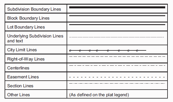
DDD. The following line types shall be used between plats in the City of Moses Lake. Line types that are used shall be consistent with the examples shown below, and shall be described in the plat legend. Where the line types shown and described coincide with each other or with other described line types, the line type that is closer to the top of the list shall be the dominant line shown on the plat.
EEE. All lot numbers and block numbers for the subdivision shall be Arabic numerals.
FFF. All blocks shall be consecutively numbered, beginning with the number 1.
GGG. All lots within a single block shall be consecutively numbered, beginning with the number 1. (Ord. 3025, 5/23/23; Ord. 2949, 4/14/20; Ord. 2672, 2/12/13; Ord. 2618, 6/28/11; Ord. 2576, 7/27/10)